目前查詢
歷史查詢
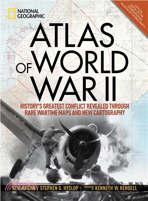
Atlas of World War II :history's greatest conflict revealed through rare wartime maps and new cartography /
作者 : Hyslop, Stephen G.,1950-. ,(Stephen Garrison), , Rendell, Kenneth W. , Kagan, Neil.
出版社 : National Geographic Partners,
出版年 : 2018
ISBN:9781426219719
3 分
- 館藏(1)
- 書目資訊
- 心得(0)
- 機讀格式
- 標籤
書名 : Atlas of World War II :history's greatest conflict revealed through rare wartime maps and new cartography /
紀錄類型 : 書目-語言資料,印刷品: 單行本
正題名[資料類型標示]/作者 : Atlas of World War II :Neil Kagan [editor], Stephen G. Hyslop [author] ; foreword by Kenneth W. Rendell ; Gregory Ugiansky, cartographer.
其他題名 : history's greatest conflict revealed through rare wartime maps and new cartography /
其他題名 : History's greatest conflict revealed through rare wartime maps and new cartography.
作者 : Hyslop, Stephen G.(Stephen Garrison),
其他作者 : Rendell, Kenneth W.
出版者 : Washington, D.C. :National Geographic Partners,[2018]
面頁冊數 : 255 pages :illustrations (some color), maps ;36 cm.
內容註 : Prelude to war, 1941: Blitzkrieg -- Prelude to war, 1943: war in the Pacific -- 1942-1944: breaking Hitler's grip -- 1944-1945: victory over Germany -- 1943-1945: defeating Japan.
標題 : World War, 1939-1945
ISBN : 9781426219719 (hbk.) :
發表心得
LEADER 02042cam a2200241 a 4500
001 978579
005 20190926092822.0
008 190930t20182018dcua g be 001 0 eng d
010 $a 2018377483
020 $a9781426219719 (hbk.) :$cNT1423
035 $aNO000181075
037 $a公共圖書館臺南分區資源中心
040 $aTWTNM$beng$dTWTNM
050 00$aG1038$b.H97 2018
082 04$a940.5410223$222
090 $a臺南市立圖書館
100 1 $aHyslop, Stephen G.$q(Stephen Garrison),$d1950-.
245 10$aAtlas of World War II :$bhistory's greatest conflict revealed through rare wartime maps and new cartography /$cNeil Kagan [editor], Stephen G. Hyslop [author] ; foreword by Kenneth W. Rendell ; Gregory Ugiansky, cartographer.
246 30$aHistory's greatest conflict revealed through rare wartime maps and new cartography.
260 $aWashington, D.C. :$bNational Geographic Partners,$c[2018]
300 $a255 pages :$billustrations (some color), maps ;$c36 cm.
504 $aIncludes bibliographical references (page 252) and index.
505 0 $aPrelude to war, 1941: Blitzkrieg -- Prelude to war, 1943: war in the Pacific -- 1942-1944: breaking Hitler's grip -- 1944-1945: victory over Germany -- 1943-1945: defeating Japan.
520 $a"This magnificent atlas delves into the cartographic history of WWII: naval, land, and aerial attacks from the invasion of Poland to Pearl Harbor and the Battle of the Bulge. Rare maps include a detailed Germany & Approaches map used by Allied forces in the final stages of the war, full large-scale wartime maps of the world used by President Roosevelt, and crucial Pacific theater maps used by B-17 pilots. Satellite data renders terrain as never before seen, highlighting countries and continents in stunning detail to include the towns, cities, provinces and transportation roads for a pinpoint-accurate depiction of army movements and alliances. Gripping wartime stories from these hallowed fields of battle, along with photographs, sketches, confidential documents, and artifacts color the rest of this timeless and informative book"--$cPublisher's description.
650 0$aWorld War, 1939-1945$vAtlases.
650 0$aWorld War, 1939-1945$xCampaigns.
650 0$aWorld War, 1939-1945$xCampaigns$vMaps.
653 $a知識性
700 1 $aRendell, Kenneth W.
700 1 $aKagan, Neil.